Attractions
A rock hunter's paradise surrounds Quartzsite with agates, limonite cubes, gold, and quartz being just a few. In town, the Hi Jolly Monument honors the Greek & Syrian camel driver, Hadji Ali, who took part in an unsuccessful 1850's U.S. War Department attempt to use camels as beasts of burden in the desert. To the south rise the Kofa Mountains. Historic and scenic areas include the Spanish Wall, Crystal Hill, Tyson Tanks, and Tyson Wells Museum. South in the Kofa Mountains is Palm Canyon, a tight gorge and home of Arizona's only native palms, reached by a steep but rewarding climb. Farther south is Castle Dome Peak. There are many points of interest including historical sites, day trips and many off road ATV trails.
Day Trips Around Quartzsite
Arizona Peace Trail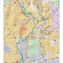
Explore the new Arizona Peace Trail, a loop system of off-highway trails from Yuma to Bullhead City. ArizonaPeaceTrail.org
Joseph Cone's Cabin Directions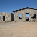
Drive west from Quartzsite on the frontage road that parallels I-10 on the south, 1.5 miles beyond Love's Truck stop Gas Station. Turn left on the asphalt road (which leads to rainbow acres) for 1.1 miles until you see a dirt road taking off to your left. At this point the cabins are visible a short distance away.
Alamo Lake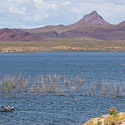
38 miles north of Wenden, Alamo Lake offers excellent bass, bluegill and catfish. Nature lovers appreciate the abundance of wildflowers in the spring and year-round wildlife including fox, coyote, mule deer, wild burro, javelina , bald and golden eagles and waterfowl.
http://azstateparks.com/Parks/ALLA/
Harquahala Mine and Cemetery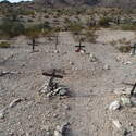
Harquahala road provides a scenic drive on good dirt roads for a high-profile 2 wheel drive vehicles past numerous deserted gold and copper mines. The mining camp cemetery is marked with wooden crosses. One of the richest strikes in the area was Harqua Hala Bonanza Mine. Herbert Hoover visited these mines for a San Francisco investment company around 1896. It is said that Wyatt Earp mined in the vicinity.
http://www.ghosttownaz.info/harquahala-mine-cemetery.php
Indian Springs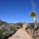
Massive granite boulders and rock formations make Indian Springs a unique place to visit. Granite from the quarry at the site was used for an addition to the Arizona State Capitol in 1949. Part of the road travels down a wash. A 4-wheel drive vehicle is recommended.
Swansee Ghost Town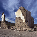
Ruins of this one-time copper producing mining town can be visited using a high profile, 2-wheel drive vehicle. At one time over 500 miners lived and worked at this site. Please do not drive off unmarked road.
Photo courtesy of S.Martin Shelton
http://www.ghosttowns.com/states/az/swansea.html
Kofa Queen Canyon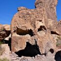
Turn on Palm Canyon road. Go approx. 4.5 miles to Kofa Queen Canyon. Take fork to the left (N), travel 4 miles until you reach the mouth of the Canyon and the base of the Signal Peak (3800" rock mountain rises like a crown off desert floor). The Canyon lies along the northern base of Signal Peak and follows an easterly route into the heart of the Kofa Mountains. 4-wheel drive rough road, unmaintained roads, only foot & horseback travel is permitted in areas bordering these trail. (go approx. 4 miles to original site of Kofa Queen Mine.)
https://www.fws.gov/uploadedfiles/kofatearsheet_2014_508.pdf
The Great Tree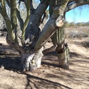
A short distance from Quartzsite Town Hall is this wonderful Native Ironwood Tree that is 1050 years old.
Sites To See In The Area
HI JOLLY MONUMENT & CEMETERY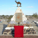
The Hi Jolly Memorial at the cemetery in Quartzsite pays tribute to Hadji Ali, one of several camel drivers brought over by the U.S. Army in a failed attempt to introduce camels to the American Southwest. After the experiment was abandoned, Ali was the only driver to remain in Arizona. He took up prospecting, and became known to locals as "Hi Jolly".
http://www.ci.quartzsite.az.us/index.php/2013-01-08-06-33-10/hi-jolly-cemetary-2
DRIPPING SPRINGS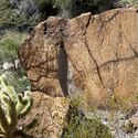
There are hundred of Petroglyphs here. You will also find the remains of an old stone cabin and an arrastre. Look along the base of the cliff to the left of the stone cabin for the cave where the spring originates. Once you've found it, listen and you will hear it dripping from the cave roof, forming a year round pool of water. A path takes off to the left of the cave, following the edge of the cliff where more petroglyphs can be seen.
How to get there: Dripping springs is one mile down the road from Dos Picachos Mine. The road is steep and rutted. This is a trip for a 4-wheeled drive vehicle.
GRINDING HOLES AND PETROGLYPHS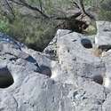
On the East side of Tyson Wash a short distance south of Quartzsite, you can see Indian grinding holes and some faint petroglyphs. There is also a natural tank near the cliff which may have water in if it has rained. This is also the site of the original Quartzsite with was washed away in a flood and subsequently rebuild on higher ground at its present location. It is said that a safe full of gold lies buried beneath the sand at the bottom of Tyson Wash somewhere near this spot, carried away in the great flood.
How to get there: Go South on highway 95 and turn right into the BLM Long Term Visitor Area, then whole Town. Her love of nature, her desire to save the environment, and dreams of people working together have been taken to heart by this little desert community.
PALM CANYON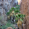
This is the only Canyon in Arizona where you can find a canyon of Palm Trees. The palms are a short walk from the parking area at the base of the mountains.
How to get there: Drive South on Highway 95 for 23 miles then turn left into the Kofa Wildlife Refuge for approximately 7 miles on the dirt road until it ends.
https://www.fws.gov/uploadedFiles/
PalmCanyonFactSheet2014_508.pdf
QUARTZSITE ROCK ALIGNMENT & INTAGLIOS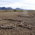
The area north of Quartzsite was used as a training ground for General Patton's troops during World War II. On this trip you will see rocks laid out in the desert for airplanes to see, spelling out QUARTZSITE and forming an arrow pointing the way.
Up the road from the Quartzsite Rock alignment there is a picture that would also be best seen from the air. It is the Fisherman Intaglio, the outline of a fisherman drawn on the desert floor by ancient Indians. Both the Rock Alignment and Fisherman Intaglio are a short walk from the asphalt road.
How to get there: North out of Quartzsite on Highway 95 for 5.4 miles, then turn right on Plomosa Road. 6 miles up the road look for fences on your left. Inside the farthest fence you will find the Rock Alignment and 1.3 miles farther up the road you come to a second "scenic view parking" sign. Park and follow path up the hill to see the Intaglios.
If you have the time and the urge look for the Indian Lookout and Stagecoach Station ruins just ahead.
KOFA NATIONAL WILDLIFE REFUGE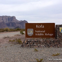
For 57 miles, US 95 cuts through the desert of Southwest Arizona - quite flat, perfectly straight and aligned exactly north-south, and interrupted only by the small town of Quartzsite. In the mild seasons of winter and early spring, much traffic uses the road, bringing sun seekers from all over the US to Yuma and on into Mexico, but few travel to this region in summer, when temperatures of over 120oF are not uncommon. Rain falls on only a few occasions each year - the summer thunderstorms that affect the higher areas of Arizona rarely extend this far. South of Interstate 10, US 95 is bordered by the Yuma Proving Ground to the west and the Kofa National Wildlife Refuge to the east - a protected area 25 x 40 miles in extent with no paved roads or facilities of any kind. The refuge is an excellent place for viewing desert plants and wildlife, rock climbing, exploring old mines, or just camping in remote wilderness.
TYSON WELLS STAGE STOP MUSEUM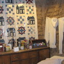
Tyson's Well Stage Station- Museum is operated by the Quartzsite Historical Society Inc. The original adobe stage station was built in 1866 by Charley Tyson at its present location. It was an important way station on the California - Arizona line because of excellent water and grass for the horses. Miners and freighters, hauling mining equipment and military supplies from the river port at Ehrenberg, AZ also stopped here.
The Quartzsite Historical Society opened Tyson's Well Museum in February 1980, after extensive restoration work. The original structurally sound walls were retained and others were rebuilt. A shell of stabilized adobe brick was built around the original walls to protect them.
http://glotours.blogspot.com/2009/01/tysons-wells-stage-station-museum.html
CELIA'S RAINBOW GARDENS & NATURE TRAIL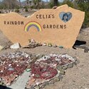
A community working together to make a child's dream come true. Celia's Rainbow Gardens, located in the Quartzsite Town Park encompasses 8 acres of the 40 acre park. The gardens were inspired by the dreams of Celia Winer, an 8-year old girl whose goal in life was to make the world a better place. Celia was a happy, bright and sensitive little girl who loved everyone. Her death from a viral heart infection on October 25, 1994 affected the whole Town. Her love of nature, her desire to save the environment, and dreams of people working together have been taken to heart by this little desert community. http://www.celiasrainbowgardens.com
CIBOLA NATIONAL WILDLIFE REFUGE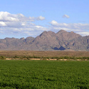
Cibola National Wildlife Refuge is located in the flood plain of the lower Colorado River and surrounded by a fringe of desert ridges and washes. The refuge encompasses both the historic Colorado River channel as well as a channelized portion constructed in the late 1960's. Along with these main water bodies, several important backwaters are home to many wildlife species that reside in this portion of the Sonoran Desert. Because of the river's life sustaining water, wildlife here survives in an environment that reaches 120 degrees in the summer and receives an average of only 2 inches of rain per year. We invite you to visit and enjoy the many wildlife-oriented activities the refuge has to offer and enjoy the scenic beauty of this oasis in the desert.
Getting There from Blythe, CA: Drive approximately 3 miles west on I-10 to Neighbors Boulevard/78 exit. Travel south on Neighbors for 12 miles to the Cibola Bridge. After crossing the bridge, continue south for 3.5 miles to headquarters.
THE CABIN AT GOODMAN MINE
It is believed this cabin was once lived in by Angela Scott, one of Quartzsite's earliest pioneers. The cabin has two rooms and is chinked with mud. It has a splendid view of the Colorado River and valley below. Follow the trail past the cabin to see old mine shafts and more stone buildings. The cabin is located at the end of a rough mining road you can get to within 1/4 mile of it.
How to get there: Travel west on I-10. Between mile markers 11 and 10 and just beyond a road cut is the runoff. Be careful the road is hard to see. You may need to open the gate to continue. Follow the rough mining road to its end and do not take any of the turnoffs. You will spot the cabin at the top of the final and steepest hill.